
Summer is with us- time to get out and about especially with energy filled children! Unfortunately, Bath has very poor main road cycling infrastructure BUT it is surprising easy to get around without going on main roads or having to navigate major junctions.
To that end, we have done a ‘Bath hacked’ map to show you where all the best low/no traffic routes are. The core network is in thickest green lines, that being the canal, the river path and the Two Tunnels (2T). We marked the schools, main play areas and some key attractions.
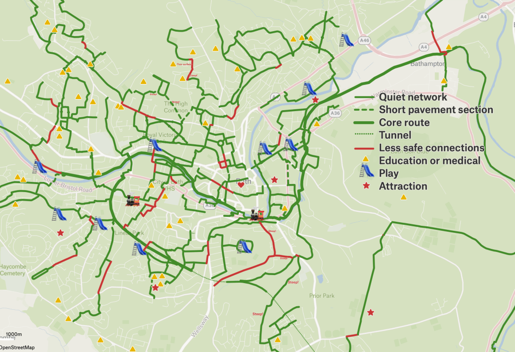
On occasions the map takes you along pavements for very short distances or over pedestrian crossings. This is definitely not ideal BUT you will find when cycling with children people are generally very understanding of what you are doing ie. having to avoid road danger because children are not provided for. As ever, ‘share with care’… (Technically it is a civil offence BUT there is a longstanding instruction to police to not take action where children are cycling on pavements to avoid dangerous roads). Failing all else, you may prefer to get off and push these distances if you are physically able to.
We have used ‘with children’ in a loose sense, is so far as Bath is steep and tackling some of the hills with a child on a long tail ecargo bike is a different kettle of fish to them cycling alongside you. You may wish to check out the gradients yourself before doing a family cycle up Fox Hill for instance! Indeed, it is generally best to check out routes in advance.
In one or two places there are no sensible connections on the road or the pavement (too narrow, too congested, one-ways etc). In those cases there is a red line. You may want to avoid these, or if you are confident then take up the whole lane with your children on the kerb side of you, the adults closer to the middle. This is called ‘riding primary’ and it the way assertive cycling is instructed. You should also stay at least 1 meter from parked vehicles in case someone opens a car door without looking. It shouldn’t be like this and WRB are working to get politicians to deliver better. You can help by writing to your councillor.
The extent of the network will evolve over time, notably as new low traffic neighbourhoods (LTNs) come online, the next being the Circus area and Lansdown Crescent area from mid July. We will keep the map up to date so you can bookmark it and refer back to it as required. The map does helps to illustrate how much of a contribution LTNs are making to active travel in Bath- and how obvious the gaps are becoming is areas such as southwest Bath where no motor traffic filters are being deployed.
We hope this map allows you to find the best routes for you and you enjoy the many benefits of active travel! And if you have any ‘hacks’ of your own to add, please put them in the comments.

2 routes I use and recommend
One way down only, St Stephen’s Road to Camden Row, there is a section of foot path but it’s smooth and flat and you can see any pedestrian coming before you start. It gets you half way down Lansdown Rd which is to be avoided. It’s really steep, I don’t think I can cycle up it even with my electric bike. Hence I think it’s a down route only.
St Margaret’s Hill to Lower Hedgemead I have just started to use this route again it’s steep but doable on an electric bike
Anne
LikeLike
Thanks for these!
LikeLike
[…] require investment on main roads too. That connectivity is something explored in the WRB map on ‘cycling with children this summer’ which could equally be called ‘cycling for people who are rightly scared for sharing road […]
LikeLike