[EDIT 22nd May 2016: Bath Hacked have now released an interactive tool which you can read about here]
For those of you who are not aware, I’m an I.T. guy and have been involved with Bath Hacked for some time, even winning hackathons a few times. Bath Hacked has one hell of a reputation, been mentioned in parliament and is internationally known for their work with open data.
In January 2015 I approached Strava to ask if they would provide to Bath Hacked the 2015 Bath Strava Metro data set for free using the reputation Bath Hacked has garnered. A year later, Strava finally provided the 2015 data set to Bath Hacked. A data set valued at around £10,000.
Strava Metro
Strava Metro is a data service providing “ground truth” on where people ride and run. Millions of GPS-tracked activities are uploaded to Strava every week from around the globe. In denser metro areas, nearly one-half of these are commutes. These activities create billions of data points that, when aggregated, enable deep analysis and understanding of real-world cycling and pedestrian route preferences.
Bath Hacked have already written an initial set of articles about the data and will be following up with more analysis as we, and by that I mean you, start asking deeper questions of the data:
- Strava Metro: what can it tell us about cycling in Bath?
- Strava Metro: first steps
- Strava Metro: activity profiles
- Strava Metro: mapping cyclist activities (*)
- Strava Metro: animating the data (*)
The articles marked with a (*) have all the pretty pictures in them.
However the question is, what can 12,139 Strava Athletes tell us about cycling in Bath? More importantly how can CycleBath and the council use it to effect a more intelligent delivery of infrastructure?
Unfortunately this next bit is going to be very image intensive but do stay with me.


Data licensed from Strava. Some data © Open Street Map contributors. Contains OS data © Crown copyright 2016

Data licensed from Strava. Some data © Open Street Map contributors. Contains OS data © Crown copyright 2016

Data licensed from Strava. Some data © Open Street Map contributors. Contains OS data © Crown copyright 2016
This video showing how slow/awkward the the Two Tunnels/Lidl/Fieldings Bridge/River Path interaction is.

Now bringing something else into the mix, my idea for Scholars Way
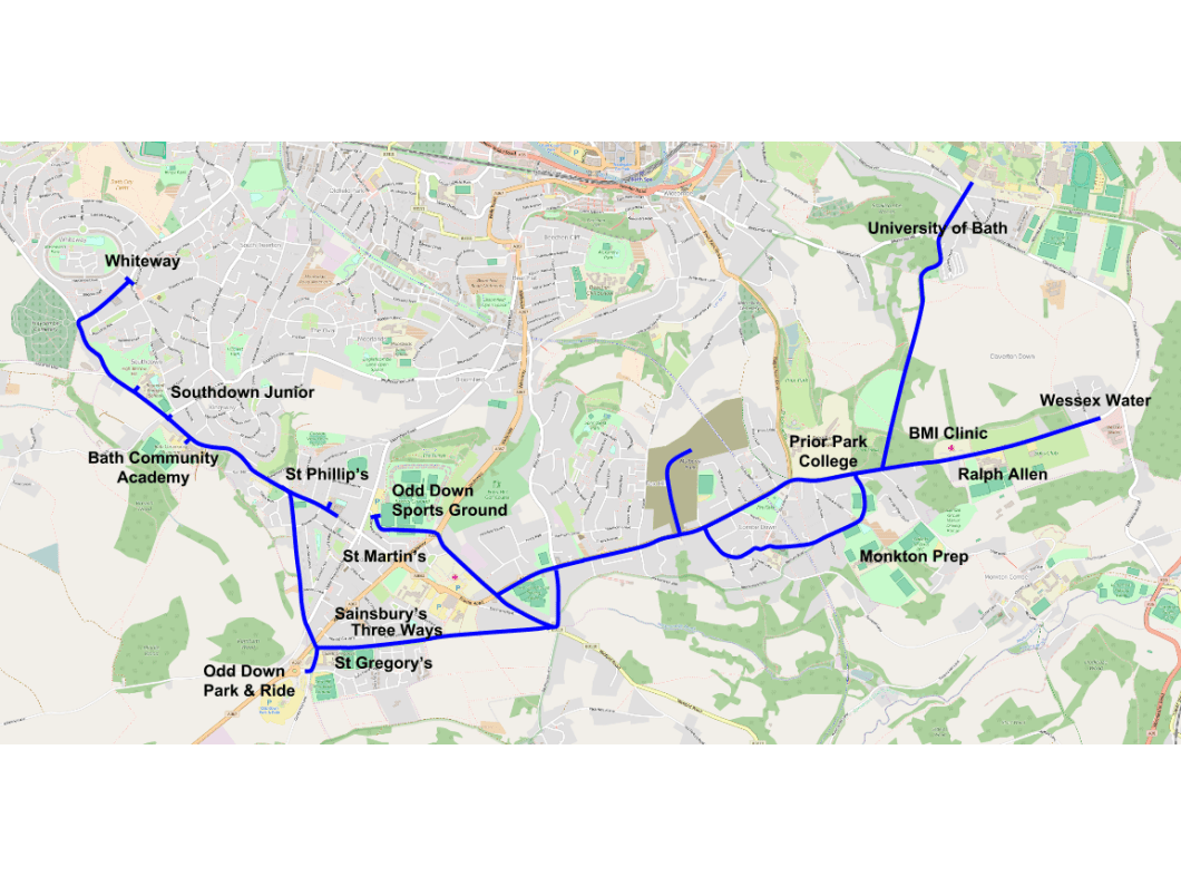
What’s pretty obvious from all this:
- The proposed Sustrans Cycle routes are not complete or the priority is wrong:
- Twerton is majorly more important than is currently understood. I mean it’s even hidden by the legend.
- Sion Hill is not a priority route.
- Bathwick Hill should also look at North Road.
- The data is from Strava Athletes. Kids do not use Strava. We need to build protected cycle tracks from the heart of communities to schools, particularly Scholar’s Way needs building. The data does not tell us this.
- Combe Down and Lansdown suffer from poor cycling even for Strava Athletes but looking at the topography, this makes almost sense.
- The river path needs more investment to have the bridge pinch points addressed, Fieldings Bridge widened, siding out the existing path, and resurfacing.
- A route is needed from London Road down St John’s Road, over a new bridge from Widcombe to the back of the railway station, under skew bridge, along the back of the bus station and to the river path.
- Councillor Tony Clarke would like to provide an alternative for cyclists to use instead of London Road. This is a huge cycling corridor and the alternative is protected cycle lanes ON London Road not a detour away from it. Cyclists use direct routes over slow detours.
- In discussion with Strava we gave them areas, Bath only and BaNES. We weren’t able to get BaNES however BaNES is only twice as big as Bath alone, but so is the population distribution. It would have been good to get BaNES data set.
Where next:
- The big maps are great but can hide lower levels of cycling in an area due to the noise of the B2B path. I want to have a more detailed look at Twerton and Weston excluding all other segments. In fact Ward level maps might be good.
- These maps are generated from ALL 2015 data. Would be good to start looking at Monday to Friday.
- There is huge depth to this data.
- We can tell how many athletes travelled through a location. How does this relate to DfT traffic counts and BaNES path counts?
- How many stop starts are there on a road/route? Each stop effectively adds 100m to a journey through getting back up to speed.
- We tried looking at the directions and speeds people were travelling through an area, but this needs a lot more work. It’s bringing up false signals:
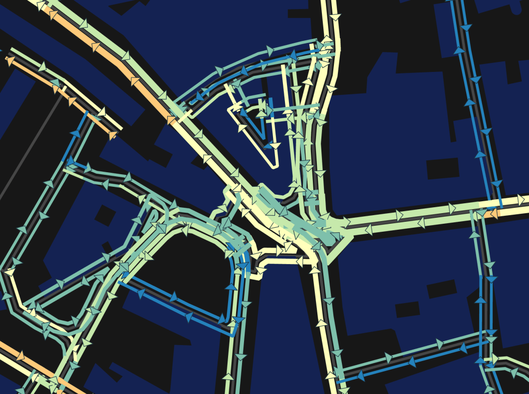
People cycling inside restaurants in the Seven Dials. Note people cycling down Monmouth Street and down Westgate Building the wrong way. More work to be done on this before it is released. Data licensed from Strava. Some data © Open Street Map contributors. Contains OS data © Crown copyright 2016
I ask you to look at these maps and draw your own conclusions and add them as a comment below. They will be acted upon.
I’d like to thank Strava and Bath Hacked for the opportunity to work with a sample of their Metro dataset. It’s a fantastic insight into cycling activity around the city. I am just gutted we do not have all of the BaNES data set.

One thing that is quite telling is that cycling in Lansdown is very low due to the topography. Cllr Anthony Clarke’s ward is Lansdown. He has the cabinet brief for Transport and has stated that investment in cycling is illogical as it does little to reduce congestion in Bath. He is a doctor.
LikeLike
He should try telling that to those of us that use Camden Road (the Western end of which is in Lansdown).
LikeLike
I read 25% of traffic is caused by school runs, so it would make sense to make sure all children can safely cycle to school. Currently I’m guessing hardly any do since it’s just not safe. In Germany or Holland children cycle to school, here they are driven by car.
LikeLike
Evidence that the likes of Monmouth St heading through 7 Dials is used by people even though a formal contraflow is not in place.
LikeLike
Frank, definitely needs to be stated. They are about to put in place a loading bay which will make this extremely dangerous.
LikeLike
Why can’t you get the BANES data?
LikeLike
It was down to the generosity of what Strava would give us for free. Interestingly enough I think there are bigger cycling issues on roads in NES than there are in Bath.
LikeLike
That’s my data 🙂 (I switch on Strava for all my trips, whether that is Club rides, commutes or general ‘riding about’.
It is true though that Strava users tend to be confident sports cyclists and, as Adam says, we need to take that into account.
What a great piece of work though 🙂
LikeLike
[…] Bath Hacked, https://cyclebath.org.uk/2016/03/25/is-there-value-in-the-bath-strava-data/, Bath Hacked study Strava Metro data, […]
LikeLike